About the DRYvER project: Drying rivers and climate change
River networks are among Earth’s most threatened hot-spots of biodiversity and are essential for human well-being. However, climate change and increased human water use are causing more rivers and streams to dry, but these drying river networks (DRNs) have received little attention. DRYvER is a Horizon 2020 project, which aims to collect, analyse and model data from nine DRNs in Europe and South America to create a novel global meta-system approach that incorporates hydrology, socio-economics, ecology and biogeochemistry in order to craft strategies, tools, guidelines, and recommendations for adaptive management of river networks in the EU and worldwide. More information is available on the DRYvER web-page.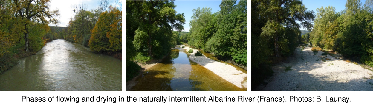

Datry T, Allen D, Argelich R, Barquin J, Bonada N, Boulton A, Branger F, Cai Y, Cañedo-Argüelles M, Cid N, Csabai Z, Dallimer M, de Araújo JC, Declerck S, Dekker T, Döll P, Encalada A, Forcellini M, Foulquier A, Heino J, Jabot F, Keszler P, Kopperoinen L, Kralisch S, Künne A, Lamouroux N, Lauvernet C, Lehtoranta V, Loskotová B, Marcé R, Martin Ortega J, Matauschek C, Miliša M, Mogyorósi S, Moya N, Müller Schmied H, Munné A, Munoz F, Mykrä H, Pal I, Paloniemi R, Pařil P, Pengal P, Pernecker B, Polášek M, Rezende C, Sabater S, Sarremejane R, Schmidt G, Senerpont Domis L, Singer G, Suárez E, Talluto M, Teurlincx S, Trautmann T, Truchy A, Tyllianakis E, Väisänen S, Varumo L, Vidal J-P, Vilmi A, Vinyoles D (2021) Securing Biodiversity, Functional Integrity, and Ecosystem Services in Drying River Networks (DRYvER). Research Ideas and Outcomes 7: e77750. https://doi.org/10.3897/rio.7.e77750
DRYvER-Hydro application
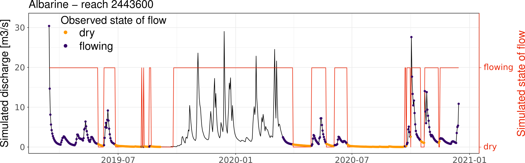
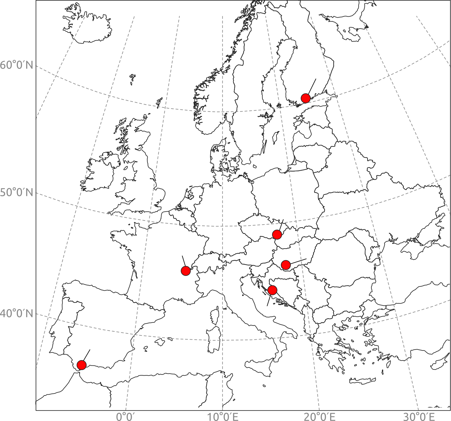
As part of the DRYvER project, a spatial hydrological model for simulating the flow intermittence in river networks was developed and implemented on 6 European river networks (see the Modelling method tab). This application shows the results of flow intermittence modelling in the 6 studied river networks: Albarine (France), Bükkösdi (Hungary), Butižnica (Croatia), Genal (Spain), Lepsämänjoki (Finland), and Velička (Czech Republic). DRYvER-Hydro allows to explore the evolution of the spatio-temporal patterns of flow intermittence in the river networks under the past-present climate (1960-2021) and under climate change projections until 2100. 3 types of indicators can be displayed. Spatial flow intermittence indicators giving flow condition statistics for each of the river network:- conD: Number of days with dry conditions
- conF: Number of days with flowing conditions
- durD: Maximum number of consecutive days with dry conditions
- durF: Maximum number of consecutive days with flowing conditions
- numFreDr: Absolute number of drying events
- numFreRW: Absolute number of rewetting events
- FstDrE: Julian day of first drying event per year [1-366]
- IntReg: Intermittent flow regime [perennial or intermittent]
- RelInt: Proportion of model derived river length with intermittent conditions [%]
- RelFlow: Proportion of model derived river length with flowing conditions [%]
- PatchC: Proportion of model-derived reach length with changing flowing and intermittent conditions compared to adjacent downstream reaches [%]
- Temp: Air temperature [°C]
- Precip: Precipitation [mm]
- ET: Evapotranspiration [mm]
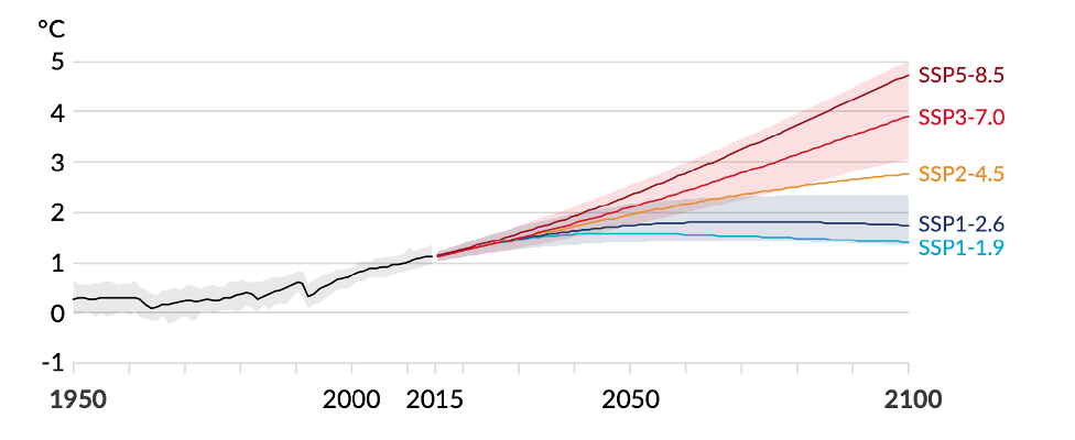
- SSP1-2.6 Sustainability
- SSP3-7.0 Regional rivalry
- SSP5-8.5 Fossil-fuelled development
Application developper | Louise Mimeau (louise.mimeau@inrae.fr)
Past/present climate modelling | Flora Branger, Annika Künne, Sven Kralisch, Louise Mimeau
Future climate modelling | Alexandre Devers, Claire Lauvernet, Jean-Philippe Vidal
Indicators analyses | Annika Künne, Sven Kralisch, Louise Mimeau
Observed flow intermittence data collection | Thibault Datry, Bertrand Launay, Amélie Truchy (Albarine, France), Zoltán Csabai, Bálint Pernecker (Bükkösdi, Hungary), Marko Miliša, Luka Polovic (Butižnica, Croatia), Amaia Angulo Rodeles, Nuria Bonada, Nuria Cid, Maria Soria (Genal, Spain), Heikki Mykrä, Henna Snåre (Lepsämänjoki, Finland), Petr Pařil (Velička, Czech Republic).
DRYvER case studies
River networks location
Flow intermittence model
In order to simulate flow intermittence, the spatially distributed process-oriented hydrological model JAMS-J2000 was implemented on the study sites. Once calibrated and validated, the JAMS-J2000 hydrological model enables to simulate daily streamflow time series in each reach of the river networks. Then, a Random Forest model (RF) predicts the daily state of flow in each reach using the simulated discharges as well as climate data and information regarding the reaches physical properties. Observed data of flow intermittence from various sources (hydrological gauging stations, phototraps, citizen science smartphone applications DRYRivERS and CrowdWater, Google Earth, and local expertise) is used to train and validate the RF model.